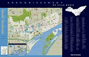
Ville-Marie Borough Map
Click on the Ville-Marie Borough Map below or on any of the following links to find out more about the borough of Ville-Marie.
Gerald Trembay - Mayor of Ville-Marie
Borough of Ville-Marie / Neighbourhoods
Electoral Districts
Borough Boundaries
|
North The boroughs of Outremont and of Cote-des-Neiges-Notre-Dame-de-Grace along the border of the Mont-Royal park. North-East The borough of Le Plateau-Mont-Royal along Sherbrooke Street, Universty Street and Park Avenue. East The borough of Mercier-Hochelaga-Maisonneuve along the CP Railway. South The Saint-Lawrence River. South-West The borough of Le Sud-Ouest along the Ville-Marie HighwayGuy StreetNotre-Dame StreetBonaventure Highway |
West The city of Westmount along Atwater Street |
Borough Maps
|
|
Ville-Marie - Ville de Montreal
Ville-Marie en statistiques / Atlas sociodemographique
Ville-Marie - Banque d'information 311
Thank you for visiting Ville-Marie Borough Map.
More to come soon.
Exit Ville-Marie Borough Map
and go to Montreal Borough Maps Home Page.
or to Montreal Business Kit Home Page.


